


Croix des Esparszates court

COMAN
User

Length
4.8 km

Max alt
904 m

Uphill gradient
182 m
Km-Effort
7.4 km

Min alt
677 m

Downhill gradient
230 m
Boucle
No
Creation date :
2021-04-23 12:01:47.972
Updated on :
2021-04-23 13:49:40.855
1h46
Difficulty : Medium

FREE GPS app for hiking
 SityTrail
IGN / Geographical institutes
SityTrail Plus
The world is yours!
About
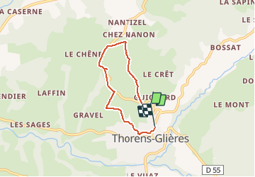
Trail Walking of 4.8 km to be discovered at Auvergne-Rhône-Alpes, Upper Savoy, Fillière. This trail is proposed by COMAN.
Positioning
Country:
France
Region :
Auvergne-Rhône-Alpes
Department/Province :
Upper Savoy
Municipality :
Fillière
Location:
Thorens-Glières
Start:(Dec)
Start:(UTM)
286977 ; 5097768 (32T) N.
Comments