


2021-04-23 Rando Saint Maurice Montcouronne

jchezlemas
User
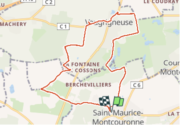

Length
10.3 km

Max alt
107 m

Uphill gradient
116 m
Km-Effort
11.9 km

Min alt
68 m

Downhill gradient
115 m
Boucle
Yes
Creation date :
2021-04-23 12:19:37.727
Updated on :
2021-04-23 16:31:51.247
2h54
Difficulty : Easy

FREE GPS app for hiking
 SityTrail
IGN / Geographical institutes
SityTrail Plus
The world is yours!
About
Trail Walking of 10.3 km to be discovered at Ile-de-France, Essonne, Saint-Maurice-Montcouronne. This trail is proposed by jchezlemas.
Positioning
Country:
France
Region :
Ile-de-France
Department/Province :
Essonne
Municipality :
Saint-Maurice-Montcouronne
Location:
Unknown
Start:(Dec)
Start:(UTM)
435230 ; 5381357 (31U) N.
Comments