Trail Walking Gourbit - Etang d' Artax via Col de Lastris et Roc de Querquéou - Photo

Etang d' Artax via Col de Lastris et Roc de Querquéou

© OpenStreetMap contributors
Length
Length
12.6 km
Max alt
Max alt
1838 m
Uphill gradient
Uphill gradient
1006 m
Km-Effort
Km-Effort  
26 km
Min alt
Min alt
868 m
Downhill gradient
Downhill gradient
1002 m
Boucle
Boucle
Yes
Creation date :
2021-04-23 07:44:26.749
Updated on :
2021-04-23 17:36:15.138

(0 Reviews)

Walking
Walking
4h55
Difficulty : Medium

Scan this QR Code to open this trail in the SityTrail application

FREE GPS app for hiking

Logo SityTrail SityTrail

IGN / Geographical institutes

Download SityTrail from the App Store Download SityTrail from Google Play

Logo SityTrail SityTrail World

The world is yours!

Download SityTrail from the App Store Download SityTrail from Google Play Download SityTrail on Huawei AppGallery

About

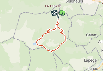
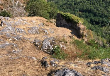
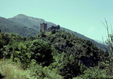
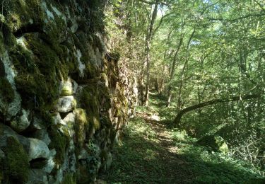
Trail Walking of 12.6 km to be discovered at Occitania, Ariège, Gourbit. This trail is proposed by toutankhcarton.

Description

Belle rando en boucle depuis le parking supérieur de Gourbit.
Boucle à effectuer de préférence en sens horaire pour profiter de la vue plongeante au lac d'Artax.
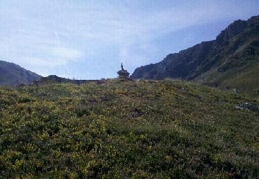
Montée de la crête du Courtal Terrous un peu raide mais vue magnifique sur la chaîne des Pyrénées.

Elevation profile

Positioning

Country:
France
Region :
Occitania
Department/Province :
Ariège
Municipality :
Gourbit
Location:
Unknown
Start:(UTM)
380156 ; 4743775 (31T) N.

Trails nearby

Trail Walking Rabat-les-Trois-Seigneurs - Pyrénées-120910 - EtangBleu - Photo
Walking
randodan

Walking

Medium
(1)
Rabat-les-Trois-Seigneurs, Occitania, Ariège, France
11.9 km | 23 km-effort
7h 45min
Yes
Trail Walking Gourbit - 04/06/2014 Rando Etang d'Artax - Photo
Walking
chrisbal

Walking

Difficult
(1)
Gourbit, Occitania, Ariège, France
10.8 km | 24 km-effort
2h 53min
Yes
Trail Walking Rabat-les-Trois-Seigneurs - Cirque D'Embans - Photo
Walking
minakara

Walking

Medium
(2)
Rabat-les-Trois-Seigneurs, Occitania, Ariège, France
8.8 km | 18.4 km-effort
3h 52min
Yes
Trail Walking Surba - Tour du roc de Sédour - Photo
Walking
c.chehere

Walking

Easy
Surba, Occitania, Ariège, France
13.1 km | 19.5 km-effort
4h 10min
Yes
Trail Electric bike Niaux - Niaux  - Photo
Electric bike
jpborto

Electric bike

Very easy
Niaux, Occitania, Ariège, France
13.8 km | 21 km-effort
51min
Yes
Trail Electric bike Niaux - Château Miglos - Photo
Electric bike
jpborto

Electric bike

Very easy
Niaux, Occitania, Ariège, France
8.1 km | 11 km-effort
45min
No
Trail On foot Lapège - Lapège et Pladetis - Photo
On foot
PRO

On foot

Easy
Lapège, Occitania, Ariège, France
10.1 km | 18.8 km-effort
4h 16min
No
Trail On foot Gourbit - Étang d'Artax - Photo
On foot
PRO

On foot

Easy
Gourbit, Occitania, Ariège, France
4.3 km | 12.3 km-effort
2h 47min
No
Trail Walking Capoulet-et-Junac - Le Vicdessos par Illié - Photo
Walking
c.chehere

Walking

Medium
Capoulet-et-Junac, Occitania, Ariège, France
14.3 km | 24 km-effort
5h 52min
Yes


Close
My subscriptions