


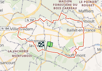
Foutue route vers Baillet

csy95
User

Length
19.1 km

Max alt
198 m

Uphill gradient
332 m
Km-Effort
24 km

Min alt
77 m

Downhill gradient
336 m
Boucle
Yes
Creation date :
2021-04-24 10:39:40.531
Updated on :
2021-04-24 10:40:39.167
5h20
Difficulty : Medium

FREE GPS app for hiking
 SityTrail
IGN / Geographical institutes
SityTrail Plus
The world is yours!
About
Trail Walking of 19.1 km to be discovered at Ile-de-France, Val-d'Oise, Chauvry. This trail is proposed by csy95.
Positioning
Country:
France
Region :
Ile-de-France
Department/Province :
Val-d'Oise
Municipality :
Chauvry
Location:
Unknown
Start:(Dec)
Start:(UTM)
446194 ; 5432919 (31U) N.
Comments