


villarnard

franquen
User
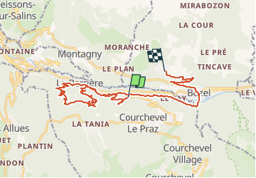

Length
19.9 km

Max alt
1178 m

Uphill gradient
1071 m
Km-Effort
34 km

Min alt
741 m

Downhill gradient
912 m
Boucle
No
Creation date :
2021-04-24 09:32:05.882
Updated on :
2021-04-24 14:44:09.034
2h24
Difficulty : Medium

FREE GPS app for hiking
 SityTrail
IGN / Geographical institutes
SityTrail Plus
The world is yours!
About
Trail Mountain bike of 19.9 km to be discovered at Auvergne-Rhône-Alpes, Savoy, Courchevel. This trail is proposed by franquen.
Positioning
Country:
France
Region :
Auvergne-Rhône-Alpes
Department/Province :
Savoy
Municipality :
Courchevel
Location:
Saint-Bon-Tarentaise
Start:(Dec)
Start:(UTM)
313464 ; 5034743 (32T) N.
Comments