![](/images/other/stat-length.png)
![Trail Walking Audenge - Graveyron-Audenge-Biganos en AR - Photo](https://media.geolcdn.com/t/1900/400/ext.pjpeg?maxdim=2&url=https%3A%2F%2Fstatic1.geolcdn.com%2Fsiteimages%2Fupload%2Ffiles%2F1553511878bg_sport_marche.png)
Graveyron-Audenge-Biganos en AR
Rosko65
User
![Length](/images/other/stat-length.png)
Length
19.3 km
![Max alt](https://static1.geolcdn.com/siteimages/upload/files/1508320355ic_sort_altitude_max_24dp.png)
Max alt
17 m
![Uphill gradient](https://static1.geolcdn.com/siteimages/upload/files/1508320355ic_sort_den_pos_24dp.png)
Uphill gradient
129 m
![Km-Effort](/images/other/stat-length.png)
Km-Effort
21 km
![Min alt](https://static1.geolcdn.com/siteimages/upload/files/1508320355ic_sort_altitude_min_24dp.png)
Min alt
-1 m
![Downhill gradient](https://static1.geolcdn.com/siteimages/upload/files/1508320355ic_sort_den_neg_24dp.png)
Downhill gradient
129 m
![Boucle](https://static1.geolcdn.com/siteimages/upload/files/16400158638029165_repeat_loop_refresh_sync_direction_icon.png)
Boucle
Yes
Creation date :
2021-04-25 07:41:41.566
Updated on :
2021-05-12 13:03:07.403
![Walking](https://static1.geolcdn.com/sitytour/trail-icons/101.png)
4h51
Difficulty : Very easy
![Scan this QR Code to open this trail in the SityTrail application](https://capi.geolives.com/qq0zvz2zws4bq2lad0pu/sitytour/trails/2761787/qr.png?size=200)
FREE GPS app for hiking
About
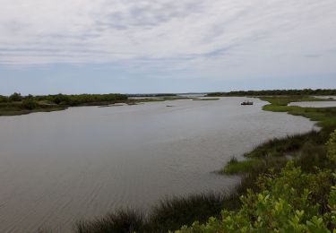
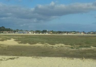
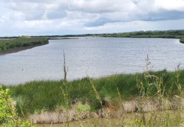
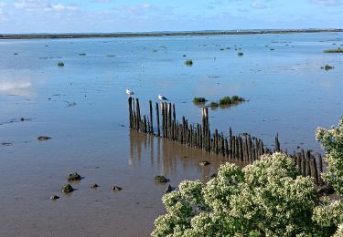
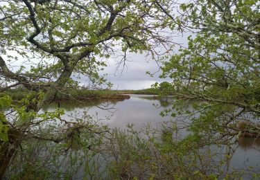
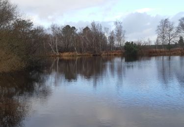
Trail Walking of 19.3 km to be discovered at New Aquitaine, Gironde, Audenge. This trail is proposed by Rosko65.
Description
En partant du parking du Domaine de Certes, nous gagnons le Port de Biganos en passant par Graveyron, Audenge. A l'aller nous longeons le bassin au plus près. Au retour nous passons sur le voie de Compostelle
Positioning
Country:
France
Region :
New Aquitaine
Department/Province :
Gironde
Municipality :
Audenge
Location:
Unknown
Start:(Dec)
Start:(UTM)
656692 ; 4950676 (30T) N.
Comments
Trails nearby
![Trail Mountain bike Lanton - Port casse Pointe aux chevaux aux jacqués Port Ares - Photo](https://media.geolcdn.com/t/375/260/ext.jpg?maxdim=2&url=https%3A%2F%2Fservices.sitytrail.com%2FGeolivesWS%2FDownloadMedia.ashx%3FTrailID%3D746063%26Media%3Dfix__20170504162400.jpg)
![Mountain bike Mountain bike](https://static1.geolcdn.com/sitytour/trail-icons/202.png)
Port casse Pointe aux chevaux aux jacqués Port Ares
Mountain bike
Medium
(1)
Lanton,
New Aquitaine,
Gironde,
France
![](/images/other/stat-length.png)
50 km | 56 km-effort
3h 59min
![](https://static1.geolcdn.com/siteimages/upload/files/16400158638029165_repeat_loop_refresh_sync_direction_icon.png)
No
![Trail Walking Lanton - Boucle Lanton - Photo](https://media.geolcdn.com/t/375/260/ext.jpg?maxdim=2&url=https%3A%2F%2Fstatic1.geolcdn.com%2Fsiteimages%2Fupload%2Ffiles%2F1553511878bg_sport_marche.png)
![Walking Walking](https://static1.geolcdn.com/sitytour/trail-icons/101.png)
Boucle Lanton
Walking
Very easy
(1)
Lanton,
New Aquitaine,
Gironde,
France
![](/images/other/stat-length.png)
11.5 km | 12.4 km-effort
2h 45min
![](https://static1.geolcdn.com/siteimages/upload/files/16400158638029165_repeat_loop_refresh_sync_direction_icon.png)
Yes
![Trail Walking Audenge - Grande boucle du domaine de Certes-Graveyron - Photo](https://media.geolcdn.com/t/375/260/ext.jpg?maxdim=2&url=https%3A%2F%2Fmedia.geolcdn.com%2Ff%2Fd70611ac-80d4-4857-ab55-0a474a592dff.jpg)
![Walking Walking](https://static1.geolcdn.com/sitytour/trail-icons/101.png)
Grande boucle du domaine de Certes-Graveyron
Walking
Easy
Audenge,
New Aquitaine,
Gironde,
France
![](/images/other/stat-length.png)
15.5 km | 16.4 km-effort
5h 0min
![](https://static1.geolcdn.com/siteimages/upload/files/16400158638029165_repeat_loop_refresh_sync_direction_icon.png)
Yes
![Trail Walking Andernos-les-Bains - ANDERNOS Les Bains - Photo](https://media.geolcdn.com/t/375/260/ext.jpg?maxdim=2&url=https%3A%2F%2Fservices.sitytrail.com%2FGeolivesWS%2FDownloadMedia.ashx%3FTrailID%3D734108%26Media%3Dfix__20170416175245.jpg)
![Walking Walking](https://static1.geolcdn.com/sitytour/trail-icons/101.png)
ANDERNOS Les Bains
Walking
Very easy
(1)
Andernos-les-Bains,
New Aquitaine,
Gironde,
France
![](/images/other/stat-length.png)
7.6 km | 8 km-effort
3h 2min
![](https://static1.geolcdn.com/siteimages/upload/files/16400158638029165_repeat_loop_refresh_sync_direction_icon.png)
No
![Trail Walking Audenge - Domaine de Certes - Photo](https://media.geolcdn.com/t/375/260/ext.jpg?maxdim=2&url=https%3A%2F%2Fstatic1.geolcdn.com%2Fsiteimages%2Fupload%2Ffiles%2F1553511878bg_sport_marche.png)
![Walking Walking](https://static1.geolcdn.com/sitytour/trail-icons/101.png)
Domaine de Certes
Walking
Very easy
(2)
Audenge,
New Aquitaine,
Gironde,
France
![](/images/other/stat-length.png)
13.2 km | 14 km-effort
2h 54min
![](https://static1.geolcdn.com/siteimages/upload/files/16400158638029165_repeat_loop_refresh_sync_direction_icon.png)
Yes
![Trail Walking Lanton - lanto' - Photo](https://media.geolcdn.com/t/375/260/ext.jpg?maxdim=2&url=https%3A%2F%2Fmedia.geolcdn.com%2Ff%2F082de4d3-0806-436c-aec0-7772c840dd81.jpg)
![Walking Walking](https://static1.geolcdn.com/sitytour/trail-icons/101.png)
![Trail Walking Lanton - PORT DE CASSIS - Photo](https://media.geolcdn.com/t/375/260/ext.jpg?maxdim=2&url=https%3A%2F%2Fmedia.geolcdn.com%2Ff%2Fdc2c4751-3afa-4c6a-ba27-22854734aa5b.jpg)
![Walking Walking](https://static1.geolcdn.com/sitytour/trail-icons/101.png)
PORT DE CASSIS
Walking
Medium
Lanton,
New Aquitaine,
Gironde,
France
![](/images/other/stat-length.png)
8 km | 8.5 km-effort
2h 19min
![](https://static1.geolcdn.com/siteimages/upload/files/16400158638029165_repeat_loop_refresh_sync_direction_icon.png)
Yes
![Trail Walking Audenge - Tour de Graveyron 13.4.23 - Photo](https://media.geolcdn.com/t/375/260/ext.jpg?maxdim=2&url=https%3A%2F%2Fmedia.geolcdn.com%2Ff%2F91ba8b9b-4867-4741-a3ba-a7cc99436673.jpg)
![Walking Walking](https://static1.geolcdn.com/sitytour/trail-icons/101.png)
Tour de Graveyron 13.4.23
Walking
Very easy
Audenge,
New Aquitaine,
Gironde,
France
![](/images/other/stat-length.png)
5.1 km | 5.3 km-effort
1h 0min
![](https://static1.geolcdn.com/siteimages/upload/files/16400158638029165_repeat_loop_refresh_sync_direction_icon.png)
Yes
![Trail Walking Audenge - étang de Mesplet - Photo](https://media.geolcdn.com/t/375/260/ext.jpg?maxdim=2&url=https%3A%2F%2Fmedia.geolcdn.com%2Ff%2F1f26339a-5b80-4908-b916-4ee9893dbd18.jpg)
![Walking Walking](https://static1.geolcdn.com/sitytour/trail-icons/101.png)
étang de Mesplet
Walking
Medium
Audenge,
New Aquitaine,
Gironde,
France
![](/images/other/stat-length.png)
8.3 km | 9 km-effort
2h 8min
![](https://static1.geolcdn.com/siteimages/upload/files/16400158638029165_repeat_loop_refresh_sync_direction_icon.png)
Yes