


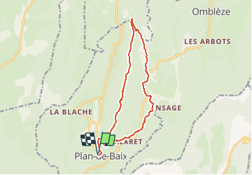
plan de baix grotte des sarazins (Tracé)

guyzinz
User

Length
15.2 km

Max alt
1014 m

Uphill gradient
736 m
Km-Effort
25 km

Min alt
538 m

Downhill gradient
736 m
Boucle
Yes
Creation date :
2021-04-26 15:58:11.446
Updated on :
2021-04-26 16:11:54.07
5h41
Difficulty : Medium

FREE GPS app for hiking
 SityTrail
IGN / Geographical institutes
SityTrail Plus
The world is yours!
About
Trail On foot of 15.2 km to be discovered at Auvergne-Rhône-Alpes, Drôme, Plan-de-Baix. This trail is proposed by guyzinz.
Positioning
Country:
France
Region :
Auvergne-Rhône-Alpes
Department/Province :
Drôme
Municipality :
Plan-de-Baix
Location:
Unknown
Start:(Dec)
Start:(UTM)
671164 ; 4964450 (31T) N.
Comments