


2021-04-26_19h16m08_J Pont dAuvers Chaponval Valhermeil retour

avdem
User
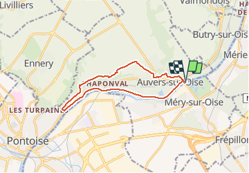

Length
11.4 km

Max alt
84 m

Uphill gradient
123 m
Km-Effort
13.1 km

Min alt
20 m

Downhill gradient
123 m
Boucle
Yes
Creation date :
2021-04-26 17:16:11.221
Updated on :
2021-04-26 17:16:13.451

FREE GPS app for hiking
 SityTrail
IGN / Geographical institutes
SityTrail Plus
The world is yours!
About
Trail of 11.4 km to be discovered at Ile-de-France, Val-d'Oise, Méry-sur-Oise. This trail is proposed by avdem.
Positioning
Country:
France
Region :
Ile-de-France
Department/Province :
Val-d'Oise
Municipality :
Méry-sur-Oise
Location:
Unknown
Start:(Dec)
Start:(UTM)
440076 ; 5435527 (31U) N.
Comments