


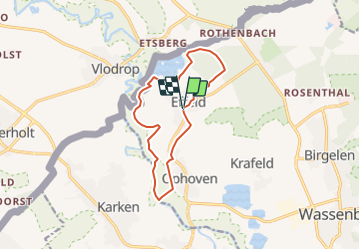
Effeld 11km
© OpenStreetMap contributors


--
Difficulty : Unknown


Length
10.9 km
Max alt
45 m
Uphill gradient
63 m
Km-Effort
11.8 km
Min alt
26 m
Downhill gradient
63 m
Boucle
Yes
Creation date :
2014-12-10 00:00:00.0
Updated on :
2014-12-10 00:00:00.0
--
Difficulty : Unknown
FREE GPS app for hiking
 SityTrail
IGN / Geographical institutes
SityTrail Plus
The world is yours!
About
Trail Walking of 10.9 km to be discovered at North Rhine-Westphalia, Kreis Heinsberg, Wassenberg. This trail is proposed by wandelgidszuidlimburg.
Description
More information on : http://www.wandelgidszuidlimburg.com
Points of interest


Positioning
Country:
Germany
Region :
North Rhine-Westphalia
Department/Province :
Kreis Heinsberg
Municipality :
Wassenberg
Location:
Unknown
Start:(Dec)
Start:(UTM)
297170 ; 5667521 (32U) N.
Comments