


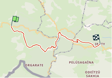
GR10 col d'Irau - col Bagargiak

winkelmuller
User

Length
12.6 km

Max alt
1430 m

Uphill gradient
854 m
Km-Effort
23 km

Min alt
994 m

Downhill gradient
557 m
Boucle
No
Creation date :
2021-04-27 13:39:30.141
Updated on :
2021-04-27 16:04:46.437
5h13
Difficulty : Difficult

FREE GPS app for hiking
 SityTrail
IGN / Geographical institutes
SityTrail Plus
The world is yours!
About
Trail Walking of 12.6 km to be discovered at New Aquitaine, Pyrénées-Atlantiques, Lecumberry. This trail is proposed by winkelmuller.
Positioning
Country:
France
Region :
New Aquitaine
Department/Province :
Pyrénées-Atlantiques
Municipality :
Lecumberry
Location:
Unknown
Start:(Dec)
Start:(UTM)
652681 ; 4768377 (30T) N.
Comments