


GR10 col Bagargiak - Logibar

winkelmuller
User
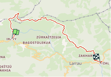

Length
16.3 km

Max alt
1420 m

Uphill gradient
426 m
Km-Effort
25 km

Min alt
391 m

Downhill gradient
1360 m
Boucle
No
Creation date :
2021-04-27 13:53:48.756
Updated on :
2021-04-28 07:09:58.476
5h51
Difficulty : Difficult

FREE GPS app for hiking
 SityTrail
IGN / Geographical institutes
SityTrail Plus
The world is yours!
About
Trail Walking of 16.3 km to be discovered at New Aquitaine, Pyrénées-Atlantiques, Larrau. This trail is proposed by winkelmuller.
Positioning
Country:
France
Region :
New Aquitaine
Department/Province :
Pyrénées-Atlantiques
Municipality :
Larrau
Location:
Unknown
Start:(Dec)
Start:(UTM)
660734 ; 4766945 (30T) N.
Comments