


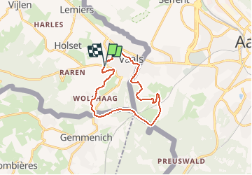
Vaals 10,8km
© OpenStreetMap contributors


--
Difficulty : Unknown


Length
10.7 km
Max alt
340 m
Uphill gradient
253 m
Km-Effort
14.1 km
Min alt
193 m
Downhill gradient
258 m
Boucle
Yes
Creation date :
2014-12-10 00:00:00.0
Updated on :
2014-12-10 00:00:00.0
--
Difficulty : Unknown
FREE GPS app for hiking
 SityTrail
IGN / Geographical institutes
SityTrail Plus
The world is yours!
About
Trail Walking of 10.7 km to be discovered at Limburg, Unknown, Vaals. This trail is proposed by wandelgidszuidlimburg.
Description
More information on : http://www.wandelgidszuidlimburg.com


Positioning
Country:
Netherlands
Region :
Limburg
Department/Province :
Unknown
Municipality :
Vaals
Location:
Unknown
Start:(Dec)
Start:(UTM)
288908 ; 5628371 (32U) N.
Comments
🇧🇪 🇳🇱 🇩🇪 Une balade transfrontalière passant par le Bois de Preus, le hameau de Wolfhaag, la belle ville de Vaals et le retour par les bois côté allemand. 👣 Bois, chemins, prairies, ville (Vaals) Après 8 mois de pluie, très très boueux !! New tracé créé. N° ?