


GR10 VARIANTE col Bagargiak - Larrau

winkelmuller
User
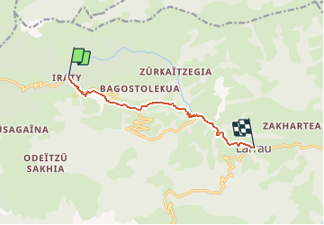

Length
8.1 km

Max alt
1328 m

Uphill gradient
145 m
Km-Effort
12.3 km

Min alt
496 m

Downhill gradient
831 m
Boucle
No
Creation date :
2021-04-27 13:53:48.756
Updated on :
2021-04-28 07:50:47.116
5h51
Difficulty : Difficult

FREE GPS app for hiking
 SityTrail
IGN / Geographical institutes
SityTrail Plus
The world is yours!
About
Trail Walking of 8.1 km to be discovered at New Aquitaine, Pyrénées-Atlantiques, Larrau. This trail is proposed by winkelmuller.
Positioning
Country:
France
Region :
New Aquitaine
Department/Province :
Pyrénées-Atlantiques
Municipality :
Larrau
Location:
Unknown
Start:(Dec)
Start:(UTM)
660734 ; 4766945 (30T) N.
Comments
Attention variante GR 10 fermée, plusieurs panneaux de fermeture et défense d'entrer...