


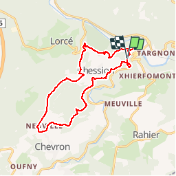
Stoumont 14km
© OpenStreetMap contributors


--
Difficulty : Unknown


Length
14 km
Max alt
444 m
Uphill gradient
436 m
Km-Effort
19.8 km
Min alt
191 m
Downhill gradient
440 m
Boucle
Yes
Creation date :
2014-12-10 00:00:00.0
Updated on :
2014-12-10 00:00:00.0
--
Difficulty : Unknown
FREE GPS app for hiking
 SityTrail
IGN / Geographical institutes
SityTrail Plus
The world is yours!
About
Trail Walking of 14 km to be discovered at Wallonia, Liège, Stoumont. This trail is proposed by wandelgidszuidlimburg.
Description
More information on : http://www.wandelgidszuidlimburg.com


Positioning
Country:
Belgium
Region :
Wallonia
Department/Province :
Liège
Municipality :
Stoumont
Location:
Rahier
Start:(Dec)
Start:(UTM)
696749 ; 5587917 (31U) N.
Comments
Très beau parcours au départ de la vallée de la Lienne. Chemins par monts etvpzr vaux avec de la neige sur les hauteurs. ➡️📄 n° 542.