


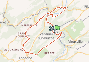
Sy 18,3km
© OpenStreetMap contributors


--
Difficulty : Unknown


Length
18.3 km
Max alt
278 m
Uphill gradient
344 m
Km-Effort
23 km
Min alt
113 m
Downhill gradient
341 m
Boucle
Yes
Creation date :
2014-12-10 00:00:00.0
Updated on :
2014-12-10 00:00:00.0
--
Difficulty : Unknown
FREE GPS app for hiking
 SityTrail
IGN / Geographical institutes
SityTrail Plus
The world is yours!
About
Trail Walking of 18.3 km to be discovered at Wallonia, Liège, Ferrières. This trail is proposed by wandelgidszuidlimburg.
Description
More information on : http://www.wandelgidszuidlimburg.com


Positioning
Country:
Belgium
Region :
Wallonia
Department/Province :
Liège
Municipality :
Ferrières
Location:
Vieuxville
Start:(Dec)
Start:(UTM)
679189 ; 5586457 (31U) N.
Comments
Splendide parcours varié ... eau/campagne/bois/hameaux/chemins panoramiques avec de magnifiques vues. n° 566.
Prachtige streek. Mocht iets minder asfalt.