


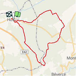
Hockai 15,9km
© OpenStreetMap contributors


--
Difficulty : Unknown


Length
15.9 km
Max alt
633 m
Uphill gradient
325 m
Km-Effort
20 km
Min alt
461 m
Downhill gradient
328 m
Boucle
Yes
Creation date :
2014-12-10 00:00:00.0
Updated on :
2014-12-10 00:00:00.0
--
Difficulty : Unknown
FREE GPS app for hiking
 SityTrail
IGN / Geographical institutes
SityTrail Plus
The world is yours!
About
Trail Walking of 15.9 km to be discovered at Wallonia, Liège, Stavelot. This trail is proposed by wandelgidszuidlimburg.
Description
More information on : http://www.wandelgidszuidlimburg.com


Positioning
Country:
Belgium
Region :
Wallonia
Department/Province :
Liège
Municipality :
Stavelot
Location:
Francorchamps
Start:(Dec)
Start:(UTM)
711889 ; 5596366 (31U) N.
Comments
Magnifique parcours 100 % neige, 100 % nature, 1% randonneur en semaine. ➡️📄 n° 606.
Très beau parcours aux paysages très variés. Le soucis est que la fin du parcours est très boueuse et difficilement accessible aux familles.