Bois de la Champelle

Nila81
User
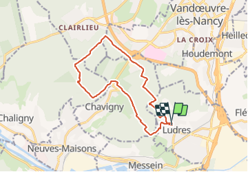

Length
13.8 km

Max alt
424 m

Uphill gradient
256 m
Km-Effort
17.2 km

Min alt
304 m

Downhill gradient
258 m
Boucle
Yes
Creation date :
2021-04-29 11:50:32.409
Updated on :
2021-08-26 18:08:49.472
2h56
Difficulty : Difficult

FREE GPS app for hiking
 SityTrail
IGN / Geographical institutes
SityTrail Plus
The world is yours!
About
Trail Walking of 13.8 km to be discovered at Grand Est, Meurthe-et-Moselle, Ludres. This trail is proposed by Nila81.
Positioning
Country:
France
Region :
Grand Est
Department/Province :
Meurthe-et-Moselle
Municipality :
Ludres
Location:
Unknown
Start:(Dec)
Start:(UTM)
290583 ; 5389470 (32U) N.
Comments