


la souche fontfreyde

raab
User
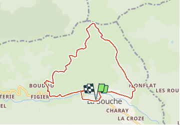

Length
9.2 km

Max alt
1022 m

Uphill gradient
528 m
Km-Effort
16.2 km

Min alt
520 m

Downhill gradient
529 m
Boucle
Yes
Creation date :
2021-04-29 14:55:43.469
Updated on :
2021-04-29 14:57:34.553
3h41
Difficulty : Medium

FREE GPS app for hiking
 SityTrail
IGN / Geographical institutes
SityTrail Plus
The world is yours!
About
Trail On foot of 9.2 km to be discovered at Auvergne-Rhône-Alpes, Ardèche, La Souche. This trail is proposed by raab.
Positioning
Country:
France
Region :
Auvergne-Rhône-Alpes
Department/Province :
Ardèche
Municipality :
La Souche
Location:
Unknown
Start:(Dec)
Start:(UTM)
595020 ; 4942499 (31T) N.
Comments