


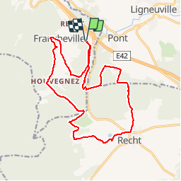
Refat 17,3km
© OpenStreetMap contributors


--
Difficulty : Unknown


Length
17.2 km
Max alt
553 m
Uphill gradient
480 m
Km-Effort
24 km
Min alt
384 m
Downhill gradient
477 m
Boucle
Yes
Creation date :
2014-12-10 00:00:00.0
Updated on :
2014-12-10 00:00:00.0
--
Difficulty : Unknown
FREE GPS app for hiking
 SityTrail
IGN / Geographical institutes
SityTrail Plus
The world is yours!
About
Trail Walking of 17.2 km to be discovered at Wallonia, Liège, Stavelot. This trail is proposed by wandelgidszuidlimburg.
Description
More information on : http://www.wandelgidszuidlimburg.com


Positioning
Country:
Belgium
Region :
Wallonia
Department/Province :
Liège
Municipality :
Stavelot
Location:
Stavelot
Start:(Dec)
Start:(UTM)
288256 ; 5583554 (32U) N.
Comments
Très beau parcours dans la nature et au calme. 📄 n° 629.