


Blanot Le Mont Saint Romain page 65

grasgilbert
User
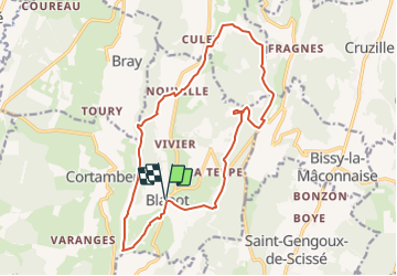

Length
14.4 km

Max alt
572 m

Uphill gradient
474 m
Km-Effort
21 km

Min alt
263 m

Downhill gradient
473 m
Boucle
Yes
Creation date :
2021-04-30 08:46:18.376
Updated on :
2025-06-13 08:46:34.518
4h43
Difficulty : Medium

FREE GPS app for hiking
 SityTrail
IGN / Geographical institutes
SityTrail Plus
The world is yours!
About
Trail On foot of 14.4 km to be discovered at Bourgogne-Franche-Comté, Saône-et-Loire, Blanot. This trail is proposed by grasgilbert.
Positioning
Country:
France
Region :
Bourgogne-Franche-Comté
Department/Province :
Saône-et-Loire
Municipality :
Blanot
Location:
Unknown
Start:(Dec)
Start:(UTM)
633104 ; 5148127 (31T) N.
Comments