


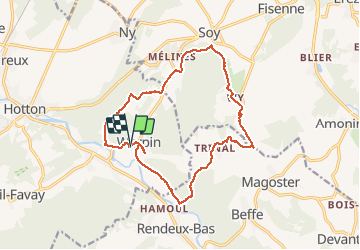
Werpin 14,3km
© OpenStreetMap contributors


--
Difficulty : Unknown


Length
14.2 km
Max alt
380 m
Uphill gradient
403 m
Km-Effort
19.6 km
Min alt
189 m
Downhill gradient
395 m
Boucle
Yes
Creation date :
2014-12-10 00:00:00.0
Updated on :
2014-12-10 00:00:00.0
--
Difficulty : Unknown
FREE GPS app for hiking
 SityTrail
IGN / Geographical institutes
SityTrail Plus
The world is yours!
About
Trail Walking of 14.2 km to be discovered at Wallonia, Luxembourg, Hotton. This trail is proposed by wandelgidszuidlimburg.
Description
More information on : http://www.wandelgidszuidlimburg.com


Positioning
Country:
Belgium
Region :
Wallonia
Department/Province :
Luxembourg
Municipality :
Hotton
Location:
Hotton
Start:(Dec)
Start:(UTM)
676979 ; 5570514 (31U) N.
Comments
N° 695 à faire