


Untitled
© OpenStreetMap contributors


--
Difficulty : Unknown


Length
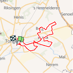
15.1 km
Max alt
122 m
Uphill gradient
131 m
Km-Effort
16.8 km
Min alt
81 m
Downhill gradient
131 m
Boucle
Yes
Creation date :
2014-12-10 00:00:00.0
Updated on :
2014-12-10 00:00:00.0
--
Difficulty : Unknown
FREE GPS app for hiking
 SityTrail
IGN / Geographical institutes
SityTrail Plus
The world is yours!
About
Trail Walking of 15.1 km to be discovered at Flanders, Limburg, Tongeren. This trail is proposed by wandelgidszuidlimburg.
Description
More information on : http://www.wandelgidszuidlimburg.com


Positioning
Country:
Belgium
Region :
Flanders
Department/Province :
Limburg
Municipality :
Tongeren
Location:
Tongeren
Start:(Dec)
Start:(UTM)
673970 ; 5628002 (31U) N.
Comments
Belle balade dans la réserve naturelle De Kevie. Faite 🌧, à refaire avec le 🌞. ℹ n°741