


autour blace

jpfrobert
User
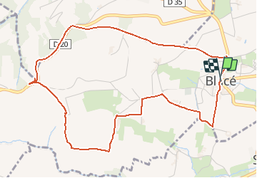

Length
5.9 km

Max alt
432 m

Uphill gradient
145 m
Km-Effort
7.9 km

Min alt
302 m

Downhill gradient
149 m
Boucle
Yes
Creation date :
2021-05-02 09:10:54.563
Updated on :
2021-05-02 09:11:26.54
1h47
Difficulty : Medium

FREE GPS app for hiking
 SityTrail
IGN / Geographical institutes
SityTrail Plus
The world is yours!
About
Trail Walking of 5.9 km to be discovered at Auvergne-Rhône-Alpes, Rhône, Blacé. This trail is proposed by jpfrobert.
Positioning
Country:
France
Region :
Auvergne-Rhône-Alpes
Department/Province :
Rhône
Municipality :
Blacé
Location:
Unknown
Start:(Dec)
Start:(UTM)
627264 ; 5098921 (31T) N.
Comments