


La grange

SityMichel
User
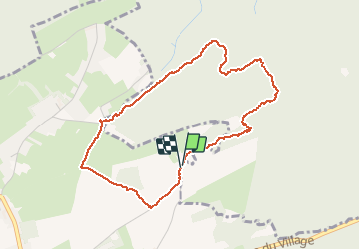

Length
3.9 km

Max alt
282 m

Uphill gradient
66 m
Km-Effort
4.7 km

Min alt
237 m

Downhill gradient
61 m
Boucle
Yes
Creation date :
2021-05-02 13:09:00.238
Updated on :
2021-05-02 14:11:56.423
1h02
Difficulty : Easy

FREE GPS app for hiking
 SityTrail
IGN / Geographical institutes
SityTrail Plus
The world is yours!
About
Trail Walking of 3.9 km to be discovered at Wallonia, Liège, Anthisnes. This trail is proposed by SityMichel.
Positioning
Country:
Belgium
Region :
Wallonia
Department/Province :
Liège
Municipality :
Anthisnes
Location:
Villers-aux-Tours
Start:(Dec)
Start:(UTM)
678742 ; 5598095 (31U) N.
Comments