


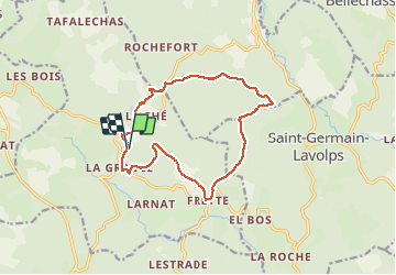
Le ruisseau de Madesclaire

viam19
User

Length
13.9 km

Max alt
904 m

Uphill gradient
381 m
Km-Effort
19 km

Min alt
685 m

Downhill gradient
384 m
Boucle
Yes
Creation date :
2021-05-02 08:05:51.052
Updated on :
2021-05-02 15:08:02.55
5h53
Difficulty : Medium

FREE GPS app for hiking
 SityTrail
IGN / Geographical institutes
SityTrail Plus
The world is yours!
About
Trail Walking of 13.9 km to be discovered at New Aquitaine, Corrèze, Saint-Sulpice-les-Bois. This trail is proposed by viam19.
Positioning
Country:
France
Region :
New Aquitaine
Department/Province :
Corrèze
Municipality :
Saint-Sulpice-les-Bois
Location:
Unknown
Start:(Dec)
Start:(UTM)
433478 ; 5051324 (31T) N.
Comments