


pernand vergeless 2

LUCIE2016
User
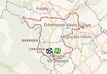

Length
23 km

Max alt
491 m

Uphill gradient
595 m
Km-Effort
31 km

Min alt
269 m

Downhill gradient
596 m
Boucle
Yes
Creation date :
2021-05-04 07:54:26.209
Updated on :
2021-05-04 13:14:08.101
4h54
Difficulty : Difficult

FREE GPS app for hiking
 SityTrail
IGN / Geographical institutes
SityTrail Plus
The world is yours!
About
Trail Walking of 23 km to be discovered at Bourgogne-Franche-Comté, Côte-d'Or, Pernand-Vergelesses. This trail is proposed by LUCIE2016.
Description
cabottes
Positioning
Country:
France
Region :
Bourgogne-Franche-Comté
Department/Province :
Côte-d'Or
Municipality :
Pernand-Vergelesses
Location:
Unknown
Start:(Dec)
Start:(UTM)
640360 ; 5215680 (31T) N.
Comments