Trail Horseback riding Lampertsloch - exp_25 Apr 2021 at 20-57-39.gpx - Photo

exp_25 Apr 2021 at 20-57-39.gpx

Promouvoir le Tourisme Equestre en Alsace GUIDE+

© OpenStreetMap contributors
Length
Length
21 km
Max alt
Max alt
532 m
Uphill gradient
Uphill gradient
658 m
Km-Effort
Km-Effort  
30 km
Min alt
Min alt
248 m
Downhill gradient
Downhill gradient
657 m
Boucle
Boucle
Yes
Creation date :
2021-05-04 21:16:56.864
Updated on :
2021-05-04 21:19:19.958

(0 Reviews)

Horseback riding
Horseback riding
3h58
Difficulty : Medium

Scan this QR Code to open this trail in the SityTrail application

FREE GPS app for hiking

Logo SityTrail SityTrail

IGN / Geographical institutes

Download SityTrail from the App Store Download SityTrail from Google Play

Logo SityTrail SityTrail Plus

The world is yours!

Download SityTrail from the App Store Download SityTrail from Google Play Download SityTrail on Huawei AppGallery

About

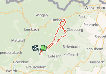
Trail Horseback riding of 21 km to be discovered at Grand Est, Bas-Rhin, Lampertsloch. This trail is proposed by Tourisme Equestre Alsace.

Description

Boucle au départ de Lampertsloch en passant par la Chapelle Climbronn et les vestiges Ligne Maginot

Elevation profile

Photos

Points of interest

Point of interest Climbach - Restaurant Auberge du Pfaffenschlick - Photo
Tourisme Equestre Alsace
Point of interest Drachenbronn-Birlenbach - auberge 7 fontaines  - Photo
Tourisme Equestre Alsace
DRACHENBRONN-BIRLENBACH 
Point of interest Lampertsloch - Refuge de Soultzerkopf - Photo
Tourisme Equestre Alsace

Positioning

Country:
France
Region :
Grand Est
Department/Province :
Bas-Rhin
Municipality :
Lampertsloch
Location:
Unknown
Start:(UTM)
412821 ; 5424198 (32U) N.


Close
My subscriptions