


sablieres mai 2021

sterdyniak
User
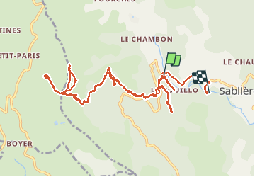

Length
15.1 km

Max alt
1074 m

Uphill gradient
726 m
Km-Effort
25 km

Min alt
409 m

Downhill gradient
769 m
Boucle
No
Creation date :
2021-05-04 07:29:29.37
Updated on :
2021-05-05 12:54:04.835
5h36
Difficulty : Very easy

FREE GPS app for hiking
 SityTrail
IGN / Geographical institutes
SityTrail Plus
The world is yours!
About
Trail Trail of 15.1 km to be discovered at Auvergne-Rhône-Alpes, Ardèche, Sablières. This trail is proposed by sterdyniak.
Positioning
Country:
France
Region :
Auvergne-Rhône-Alpes
Department/Province :
Ardèche
Municipality :
Sablières
Location:
Unknown
Start:(Dec)
Start:(UTM)
583864 ; 4931785 (31T) N.
Comments