


senlis

jojo02
User
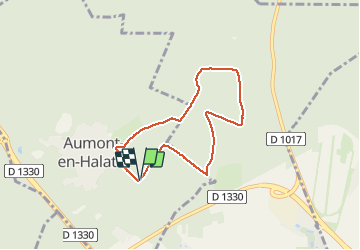

Length
5.8 km

Max alt
127 m

Uphill gradient
68 m
Km-Effort
6.7 km

Min alt
89 m

Downhill gradient
68 m
Boucle
Yes
Creation date :
2021-05-05 14:11:32.212
Updated on :
2021-05-05 14:49:41.135
37m
Difficulty : Very easy

FREE GPS app for hiking
 SityTrail
IGN / Geographical institutes
SityTrail Plus
The world is yours!
About
Trail Running of 5.8 km to be discovered at Hauts-de-France, Oise, Aumont-en-Halatte. This trail is proposed by jojo02.
Positioning
Country:
France
Region :
Hauts-de-France
Department/Province :
Oise
Municipality :
Aumont-en-Halatte
Location:
Unknown
Start:(Dec)
Start:(UTM)
468125 ; 5452694 (31U) N.
Comments