


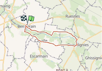
Boucle Bermerain Beaudignies

BrassensJC
User

Length
12 km

Max alt
102 m

Uphill gradient
130 m
Km-Effort
13.7 km

Min alt
55 m

Downhill gradient
129 m
Boucle
Yes
Creation date :
2021-05-06 08:43:37.072
Updated on :
2021-05-06 08:45:07.955
3h07
Difficulty : Difficult

FREE GPS app for hiking
 SityTrail
IGN / Geographical institutes
SityTrail Plus
The world is yours!
About
Trail Walking of 12 km to be discovered at Hauts-de-France, Nord, Bermerain. This trail is proposed by BrassensJC.
Positioning
Country:
France
Region :
Hauts-de-France
Department/Province :
Nord
Municipality :
Bermerain
Location:
Unknown
Start:(Dec)
Start:(UTM)
537937 ; 5566820 (31U) N.
Comments
Très bon début de randonnée mais malheureusement arrivée à mi chemin je me suis retrouvée sur une départementale, plutôt dangereux à pieds.