Trail Walking Vendegies-au-Bois - boucle de vendegies au bois - Photo

boucle de vendegies au bois

© OpenStreetMap contributors
Length
Length
7.9 km
Max alt
Max alt
137 m
Uphill gradient
Uphill gradient
68 m
Km-Effort
Km-Effort  
8.8 km
Min alt
Min alt
102 m
Downhill gradient
Downhill gradient
67 m
Boucle
Boucle
Yes
Creation date :
2021-05-06 12:25:41.428
Updated on :
2021-05-07 07:14:16.057

(0 Reviews)

Walking
Walking
1h55
Difficulty : Easy

Scan this QR Code to open this trail in the SityTrail application

FREE GPS app for hiking

Logo SityTrail SityTrail

IGN / Geographical institutes

Download SityTrail from the App Store Download SityTrail from Google Play

Logo SityTrail SityTrail World

The world is yours!

Download SityTrail from the App Store Download SityTrail from Google Play Download SityTrail on Huawei AppGallery

About

Trail Walking of 7.9 km to be discovered at Hauts-de-France, Nord, Vendegies-au-Bois. This trail is proposed by BrassensJC.

Description

Belle rando dans le bocage du pays de Mormal

Elevation profile

Positioning

Country:
France
Region :
Hauts-de-France
Department/Province :
Nord
Municipality :
Vendegies-au-Bois
Location:
Unknown
Start:(UTM)
541185 ; 5558786 (31U) N.

Trails nearby

Trail Walking Englefontaine - Circuit du Saint - Georges à Mormal - Englefontaine - Photo
Walking
tracegps

Walking

Medium
(1)
Englefontaine, Hauts-de-France, Nord, France
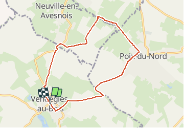
11.6 km | 13.1 km-effort
3h 0min
Yes
Trail Walking Englefontaine - Englefontaine. Lisière Mormal  - Photo
Walking
ayumi atsu

Walking

Medium
Englefontaine, Hauts-de-France, Nord, France
7.5 km | 8.5 km-effort
1h 22min
Yes
Trail Walking Bousies - Circuit « Perds-tes-Peines » (Bousies) - Photo
Walking
tracegps

Walking

Easy
Bousies, Hauts-de-France, Nord, France
3.7 km | 4.1 km-effort
1h 0min
Yes
Trail Mountain bike Fontaine-au-Bois - VTT de Fontaine au Bois - Photo
Mountain bike
tracegps

Mountain bike

Easy
(1)
Fontaine-au-Bois, Hauts-de-France, Nord, France
13.5 km | 14.8 km-effort
1h 30min
Yes
Trail Walking Salesches - Circuits des fleurs champêtres (Salesches) - Photo
Walking
tracegps

Walking

Difficult
(1)
Salesches, Hauts-de-France, Nord, France
13.2 km | 14.8 km-effort
3h 19min
Yes
Trail sport Louvignies-Quesnoy - Forêt de Mormal - Photo
sport
Roydger

sport

Very easy
Louvignies-Quesnoy, Hauts-de-France, Nord, France
49 km | 0 m-effort
Unknown
Yes
Trail Walking Englefontaine - rando 25082019 - Photo
Walking
hplateau

Walking

Very easy
Englefontaine, Hauts-de-France, Nord, France
11 km | 12.3 km-effort
3h 24min
Yes
Trail Running Louvignies-Quesnoy - Lisbonne prepa - Photo
Running
ayumi atsu

Running

Very easy
Louvignies-Quesnoy, Hauts-de-France, Nord, France
16.3 km | 18.5 km-effort
1h 44min
Yes
Trail Walking Fontaine-au-Bois - Fontaine 6 - Photo
Walking
JEANNEGREBAUX

Walking

Medium
Fontaine-au-Bois, Hauts-de-France, Nord, France
10.4 km | 11.6 km-effort
2h 34min
Yes


Close
My subscriptions