


GTVAU-J4-C

PhilippeC54
User

Length
9.5 km

Max alt
414 m

Uphill gradient
183 m
Km-Effort
11.9 km

Min alt
312 m

Downhill gradient
157 m
Boucle
No
Creation date :
2021-05-06 16:25:47.905
Updated on :
2021-05-06 16:25:47.905
--
Difficulty : Unknown

FREE GPS app for hiking
 SityTrail
IGN / Geographical institutes
SityTrail Plus
The world is yours!
About
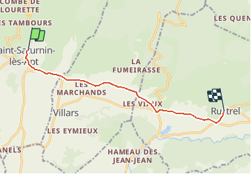
Trail Mountain bike of 9.5 km to be discovered at Provence-Alpes-Côte d'Azur, Vaucluse, Saint-Saturnin-lès-Apt. This trail is proposed by PhilippeC54.
Positioning
Country:
France
Region :
Provence-Alpes-Côte d'Azur
Department/Province :
Vaucluse
Municipality :
Saint-Saturnin-lès-Apt
Location:
Unknown
Start:(Dec)
Start:(UTM)
691549 ; 4868648 (31T) N.
Comments