


GTVAU-J7 variante

PhilippeC54
User
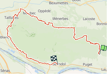

Length
47 km

Max alt
722 m

Uphill gradient
1331 m
Km-Effort
65 km

Min alt
97 m

Downhill gradient
1430 m
Boucle
No
Creation date :
2021-05-06 16:25:49.412
Updated on :
2021-05-06 16:25:49.412
--
Difficulty : Unknown

FREE GPS app for hiking
 SityTrail
IGN / Geographical institutes
SityTrail Plus
The world is yours!
About
Trail Mountain bike of 47 km to be discovered at Provence-Alpes-Côte d'Azur, Vaucluse, Lauris. This trail is proposed by PhilippeC54.
Positioning
Country:
France
Region :
Provence-Alpes-Côte d'Azur
Department/Province :
Vaucluse
Municipality :
Lauris
Location:
Unknown
Start:(Dec)
Start:(UTM)
684891 ; 4849046 (31T) N.
Comments