


vaison la romaine G1

LUCIE2016
User
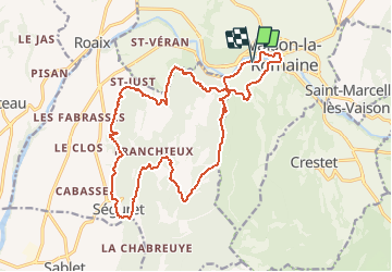

Length
21 km

Max alt
405 m

Uphill gradient
671 m
Km-Effort
30 km

Min alt
192 m

Downhill gradient
672 m
Boucle
Yes
Creation date :
2021-05-06 18:44:23.41
Updated on :
2021-05-06 18:47:07.961
6h55
Difficulty : Very difficult

FREE GPS app for hiking
 SityTrail
IGN / Geographical institutes
SityTrail Plus
The world is yours!
About
Trail Walking of 21 km to be discovered at Provence-Alpes-Côte d'Azur, Vaucluse, Vaison-la-Romaine. This trail is proposed by LUCIE2016.
Positioning
Country:
France
Region :
Provence-Alpes-Côte d'Azur
Department/Province :
Vaucluse
Municipality :
Vaison-la-Romaine
Location:
Unknown
Start:(Dec)
Start:(UTM)
664970 ; 4900493 (31T) N.
Comments