


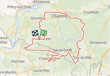
Autour de la forêt de Chantilly

domifon
User

Length
42 km

Max alt
133 m

Uphill gradient
510 m
Km-Effort
49 km

Min alt
27 m

Downhill gradient
509 m
Boucle
Yes
Creation date :
2021-05-07 13:49:52.0
Updated on :
2021-05-07 15:50:16.411
1h58
Difficulty : Medium

FREE GPS app for hiking
 SityTrail
IGN / Geographical institutes
SityTrail Plus
The world is yours!
About
Trail Mountain bike of 42 km to be discovered at Hauts-de-France, Oise, Lamorlaye. This trail is proposed by domifon.
Positioning
Country:
France
Region :
Hauts-de-France
Department/Province :
Oise
Municipality :
Lamorlaye
Location:
Unknown
Start:(Dec)
Start:(UTM)
457602 ; 5445190 (31U) N.
Comments