


2021 04 senart r1

michel1025
User
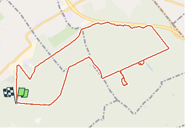

Length
12.4 km

Max alt
95 m

Uphill gradient
77 m
Km-Effort
13.4 km

Min alt
76 m

Downhill gradient
76 m
Boucle
Yes
Creation date :
2021-04-27 11:22:40.0
Updated on :
2021-05-08 09:53:23.333
2h47
Difficulty : Difficult

FREE GPS app for hiking
 SityTrail
IGN / Geographical institutes
SityTrail Plus
The world is yours!
About
Trail Walking of 12.4 km to be discovered at Ile-de-France, Essonne, Draveil. This trail is proposed by michel1025.
Positioning
Country:
France
Region :
Ile-de-France
Department/Province :
Essonne
Municipality :
Draveil
Location:
Unknown
Start:(Dec)
Start:(UTM)
458030 ; 5391146 (31U) N.
Comments