


Wikiloc - shared-route (21)

AnneCecile
User
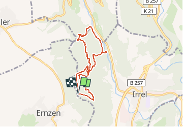

Length
6.4 km

Max alt
344 m

Uphill gradient
210 m
Km-Effort
9.2 km

Min alt
192 m

Downhill gradient
214 m
Boucle
Yes
Creation date :
2021-05-08 12:28:00.218
Updated on :
2021-05-08 12:29:41.023

FREE GPS app for hiking
 SityTrail
IGN / Geographical institutes
SityTrail Plus
The world is yours!
About
Trail of 6.4 km to be discovered at Rhineland-Palatinate, Eifelkreis Bitburg-Prüm, Irrel. This trail is proposed by AnneCecile.
Positioning
Country:
Germany
Region :
Rhineland-Palatinate
Department/Province :
Eifelkreis Bitburg-Prüm
Municipality :
Irrel
Location:
Unknown
Start:(Dec)
Start:(UTM)
315628 ; 5524752 (32U) N.
Comments