


Corrençon - Château Julien

maupassant38
User
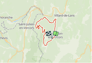

Length
25 km

Max alt
1550 m

Uphill gradient
704 m
Km-Effort
34 km

Min alt
1101 m

Downhill gradient
702 m
Boucle
Yes
Creation date :
2021-05-08 08:32:09.835
Updated on :
2021-05-08 13:06:37.434
1h42
Difficulty : Medium

FREE GPS app for hiking
 SityTrail
IGN / Geographical institutes
SityTrail Plus
The world is yours!
About
Trail Mountain bike of 25 km to be discovered at Auvergne-Rhône-Alpes, Isère, Corrençon-en-Vercors. This trail is proposed by maupassant38.
Positioning
Country:
France
Region :
Auvergne-Rhône-Alpes
Department/Province :
Isère
Municipality :
Corrençon-en-Vercors
Location:
Unknown
Start:(Dec)
Start:(UTM)
698389 ; 4988727 (31T) N.
Comments