


Col PARQUETOUT-Vers col NODRY

RD78-38
User

Length
12.6 km

Max alt
1756 m

Uphill gradient
1069 m
Km-Effort
26 km

Min alt
729 m

Downhill gradient
875 m
Boucle
No
Creation date :
2021-05-08 08:40:32.0
Updated on :
2021-05-08 13:07:26.231
2h27
Difficulty : Medium

FREE GPS app for hiking
 SityTrail
IGN / Geographical institutes
SityTrail Plus
The world is yours!
About
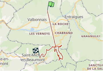
Trail Walking of 12.6 km to be discovered at Auvergne-Rhône-Alpes, Isère, Valbonnais. This trail is proposed by RD78-38.
Description
Très belle Randonnée avec superbes paysages.
Positioning
Country:
France
Region :
Auvergne-Rhône-Alpes
Department/Province :
Isère
Municipality :
Valbonnais
Location:
Unknown
Start:(Dec)
Start:(UTM)
730301 ; 4976841 (31T) N.
Comments