


pilat

ALAIN3859
User
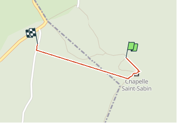

Length
472 m

Max alt
1117 m

Uphill gradient
3 m
Km-Effort
665 m

Min alt
1061 m

Downhill gradient
49 m
Boucle
No
Creation date :
2021-05-08 09:50:40.063
Updated on :
2021-05-08 15:46:49.707
1h01
Difficulty : Very easy

FREE GPS app for hiking
 SityTrail
IGN / Geographical institutes
SityTrail Plus
The world is yours!
About
Trail Walking of 472 m to be discovered at Auvergne-Rhône-Alpes, Loire, Véranne. This trail is proposed by ALAIN3859.
Positioning
Country:
France
Region :
Auvergne-Rhône-Alpes
Department/Province :
Loire
Municipality :
Véranne
Location:
Unknown
Start:(Dec)
Start:(UTM)
626877 ; 5025071 (31T) N.
Comments