


Pas du Pertuson

crocau
User
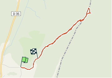

Length
4.4 km

Max alt
1440 m

Uphill gradient
324 m
Km-Effort
8.5 km

Min alt
1113 m

Downhill gradient
262 m
Boucle
No
Creation date :
2021-05-08 13:38:17.688
Updated on :
2021-05-08 17:01:49.426
2h51
Difficulty : Medium

FREE GPS app for hiking
 SityTrail
IGN / Geographical institutes
SityTrail Plus
The world is yours!
About
Trail Walking of 4.4 km to be discovered at Auvergne-Rhône-Alpes, Isère, Rencurel. This trail is proposed by crocau.
Positioning
Country:
France
Region :
Auvergne-Rhône-Alpes
Department/Province :
Isère
Municipality :
Rencurel
Location:
Unknown
Start:(Dec)
Start:(UTM)
695378 ; 5002029 (31T) N.
Comments