


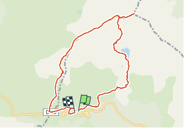
boucle pic des trois seigneurs

petit-pied
User

Length
11.2 km

Max alt
2182 m

Uphill gradient
854 m
Km-Effort
23 km

Min alt
1382 m

Downhill gradient
844 m
Boucle
Yes
Creation date :
2021-05-08 07:35:39.213
Updated on :
2021-05-08 18:55:27.9
7h46
Difficulty : Very difficult

FREE GPS app for hiking
 SityTrail
IGN / Geographical institutes
SityTrail Plus
The world is yours!
About
Trail Walking of 11.2 km to be discovered at Occitania, Ariège, Val-de-Sos. This trail is proposed by petit-pied.
Positioning
Country:
France
Region :
Occitania
Department/Province :
Ariège
Municipality :
Val-de-Sos
Location:
Suc-et-Sentenac
Start:(Dec)
Start:(UTM)
370918 ; 4740550 (31T) N.
Comments