


Etang des noes

eric.deniau
User

Length
14.8 km

Max alt
89 m

Uphill gradient
156 m
Km-Effort
16.8 km

Min alt
27 m

Downhill gradient
155 m
Boucle
Yes
Creation date :
2021-05-09 06:51:44.0
Updated on :
2021-05-09 10:25:45.295
3h32
Difficulty : Difficult

FREE GPS app for hiking
 SityTrail
IGN / Geographical institutes
SityTrail Plus
The world is yours!
About
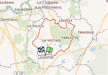
Trail Walking of 14.8 km to be discovered at Brittany, Ille-et-Vilaine, Québriac. This trail is proposed by eric.deniau.
Description
C
Positioning
Country:
France
Region :
Brittany
Department/Province :
Ille-et-Vilaine
Municipality :
Québriac
Location:
Unknown
Start:(Dec)
Start:(UTM)
586877 ; 5355242 (30U) N.
Comments
Bonjour, Le circuit "étang des Noës" que vous avez posté emprunte le bois de la Motte aux Rochers et du Moulin Neuf. Il s'agit d'un site privé qui n'accueille pas les randonnées. Pourriez-vous effectuer les modifications nécessaires ? Merci