


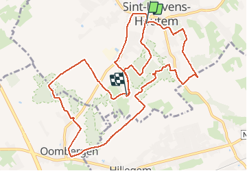
cotthem natuurwandeling

Tijgetje
User

Length
13.1 km

Max alt
85 m

Uphill gradient
160 m
Km-Effort
15.2 km

Min alt
36 m

Downhill gradient
145 m
Boucle
No
Creation date :
2021-05-09 09:08:44.404
Updated on :
2021-05-09 12:08:49.408
2h39
Difficulty : Difficult

FREE GPS app for hiking
 SityTrail
IGN / Geographical institutes
SityTrail Plus
The world is yours!
About
Trail Walking of 13.1 km to be discovered at Flanders, East Flanders, Sint-Lievens-Houtem. This trail is proposed by Tijgetje.
Positioning
Country:
Belgium
Region :
Flanders
Department/Province :
East Flanders
Municipality :
Sint-Lievens-Houtem
Location:
Sint-Lievens-Houtem
Start:(Dec)
Start:(UTM)
560286 ; 5641195 (31U) N.
Comments