


col de Bleine-Pic de l'Aiglo

alainfauvet
User
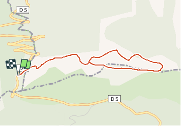

Length
4.7 km

Max alt
1583 m

Uphill gradient
179 m
Km-Effort
7.1 km

Min alt
1441 m

Downhill gradient
180 m
Boucle
Yes
Creation date :
2021-05-09 14:18:01.14
Updated on :
2021-05-11 10:30:54.592
1h37
Difficulty : Medium

FREE GPS app for hiking
 SityTrail
IGN / Geographical institutes
SityTrail Plus
The world is yours!
About
Trail Walking of 4.7 km to be discovered at Provence-Alpes-Côte d'Azur, Maritime Alps, Saint-Auban. This trail is proposed by alainfauvet.
Positioning
Country:
France
Region :
Provence-Alpes-Côte d'Azur
Department/Province :
Maritime Alps
Municipality :
Saint-Auban
Location:
Unknown
Start:(Dec)
Start:(UTM)
323356 ; 4853614 (32T) N.
Comments