


Aigueze - castel

elorthiois
User
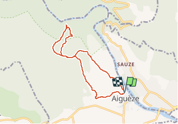

Length
7.7 km

Max alt
279 m

Uphill gradient
243 m
Km-Effort
10.9 km

Min alt
91 m

Downhill gradient
242 m
Boucle
Yes
Creation date :
2021-05-09 13:00:16.283
Updated on :
2021-05-09 15:42:28.966
2h41
Difficulty : Medium

FREE GPS app for hiking
 SityTrail
IGN / Geographical institutes
SityTrail Plus
The world is yours!
About
Trail Walking of 7.7 km to be discovered at Occitania, Gard, Aiguèze. This trail is proposed by elorthiois.
Description
Pierrailleux
Positioning
Country:
France
Region :
Occitania
Department/Province :
Gard
Municipality :
Aiguèze
Location:
Unknown
Start:(Dec)
Start:(UTM)
624039 ; 4906899 (31T) N.
Comments