Trail Walking Frontignan-Savès - 
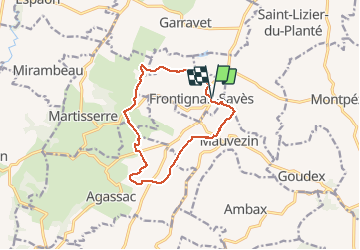
Coteaux du Comminges - Photo
 rigol05
rigol05

User

© OpenStreetMap contributors
Length
Length
12.2 km
Max alt
Max alt
323 m
Uphill gradient
Uphill gradient
279 m
Km-Effort
Km-Effort  
16 km
Min alt
Min alt
195 m
Downhill gradient
Downhill gradient
280 m
Boucle
Boucle
Yes
Creation date :
2021-05-10 08:09:46.017
Updated on :
2021-05-24 12:26:12.475

(0 Reviews)

Walking
Walking
3h13
Difficulty : Medium

Scan this QR Code to open this trail in the SityTrail application

FREE GPS app for hiking

Logo SityTrail SityTrail

IGN / Geographical institutes

Download SityTrail from the App Store Download SityTrail from Google Play

Logo SityTrail SityTrail Plus

The world is yours!

Download SityTrail from the App Store Download SityTrail from Google Play Download SityTrail on Huawei AppGallery

About

Trail Walking of 12.2 km to be discovered at Occitania, Haute-Garonne, Frontignan-Savès. This trail is proposed by rigol05.

Description

Sortie du 10 mai 2021 - passage dans le Gers
Départ Frontignan Savès
Itinéraire entièrement balisé, se méfier toutefois, à certains endroits le balisage n'est toujours pas bien disposé. Randonnée très agréable avec de beaux paysages dans un Gers bien vallonné.

Elevation profile

Photos

Positioning

Country:
France
Region :
Occitania
Department/Province :
Haute-Garonne
Municipality :
Frontignan-Savès
Location:
Unknown
Start:(UTM)
331825 ; 4806855 (31T) N.


Close
My subscriptions