


Gelderland - Rond Eibergen

gpstracks
User
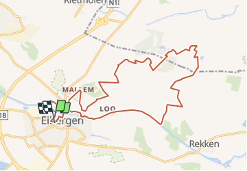

Length
18.9 km

Max alt
40 m

Uphill gradient
115 m
Km-Effort
20 km

Min alt
18 m

Downhill gradient
114 m
Boucle
Yes
Creation date :
2014-12-10 00:00:00.0
Updated on :
2014-12-10 00:00:00.0
--
Difficulty : Unknown

FREE GPS app for hiking
 SityTrail
IGN / Geographical institutes
SityTrail Plus
The world is yours!
About
Trail Walking of 18.9 km to be discovered at Gelderland, Unknown, Berkelland. This trail is proposed by gpstracks.
Description
More information on GPStracks.nl : http://www.gpstracks.nl


Positioning
Country:
Netherlands
Region :
Gelderland
Department/Province :
Unknown
Municipality :
Berkelland
Location:
Unknown
Start:(Dec)
Start:(UTM)
338856 ; 5775082 (32U) N.
Comments