


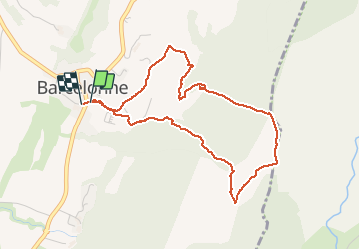
Le tour de la tour de Barcelonne

alinetpierre
User

Length
4.6 km

Max alt
473 m

Uphill gradient
182 m
Km-Effort
7.1 km

Min alt
296 m

Downhill gradient
188 m
Boucle
Yes
Creation date :
2021-05-12 08:04:16.0
Updated on :
2021-05-12 09:32:16.572
1h14
Difficulty : Very easy

FREE GPS app for hiking
 SityTrail
IGN / Geographical institutes
SityTrail Plus
The world is yours!
About
Trail Walking of 4.6 km to be discovered at Auvergne-Rhône-Alpes, Drôme, Barcelonne. This trail is proposed by alinetpierre.
Description
Jolie promenade très beau panorama
Positioning
Country:
France
Region :
Auvergne-Rhône-Alpes
Department/Province :
Drôme
Municipality :
Barcelonne
Location:
Unknown
Start:(Dec)
Start:(UTM)
662067 ; 4970307 (31T) N.
Comments