


croix de thel

jpfrobert
User
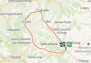

Length
30 km

Max alt
655 m

Uphill gradient
648 m
Km-Effort
39 km

Min alt
245 m

Downhill gradient
644 m
Boucle
Yes
Creation date :
2021-05-12 10:17:18.897
Updated on :
2021-05-12 10:18:11.734
2h21
Difficulty : Difficult

FREE GPS app for hiking
 SityTrail
IGN / Geographical institutes
SityTrail Plus
The world is yours!
About
Trail Road bike of 30 km to be discovered at Auvergne-Rhône-Alpes, Rhône, Légny. This trail is proposed by jpfrobert.
Positioning
Country:
France
Region :
Auvergne-Rhône-Alpes
Department/Province :
Rhône
Municipality :
Légny
Location:
Unknown
Start:(Dec)
Start:(UTM)
622143 ; 5084972 (31T) N.
Comments